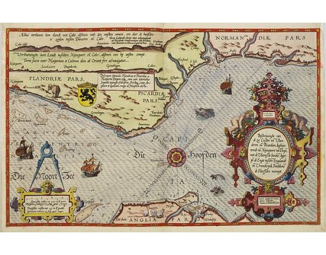
WAGHENAER, L. J. - Beschrijvinge vande de zee Cuften va Vlanderen en Picardien. . .
 Click on image to zoom

WAGHENAER, L. J. - Beschrijvinge vande de zee Cuften va Vlanderen en Picardien. . .
Published: Leiden, Plantijn, 1585
Size: 325 x 510mm.
Color: Coloured
Condition: Papier uniformément bruni. Bonne condition générale. - Marginal discolouration and paper slightly age-toned. Else good condition.
Description
Rare carte marine représentant les côtes de Flandre, Picardie et Normandie depuis Nieuwpoort jusqu'à Dieppe, avec le texte en néerlandais, publiée dans l'une des premières éditions de l'atlas maritime de Waghenaer "Spiegel der Zeevaerdt" et gravée par Baptist et Johannes van Deutecom. Elle est ornée d’un cartouche de titre Renaissance, de l'écu de Flandre, d'une échelle surmontée d'un compas, d'une rose des vents, de plusieurs navires et de monstres marins. - A detailed description of the coast of Flanders and Normandy decorated by a large coloured baroque title cartouche, and the coat of arms of Flanders with a colorful scale cartouche decorated with a compass, a compass rose, several vessels and sea monsters.
From an early Dutch text edition of this landmark contribution to the science of navigation.
Waghenaer's own personal experiences as a pilot along European coasts were used to compile the Spiegel der Zeevaerdt, the first edition which was published in Dutch at Leyden in 1584/85 by the house of Plantin. Although advertised as published in 1584 according to Koeman this edition was more likely printed in 1585.
The chart is engraved by the famous artists Baptist and Johannes van Deutecom.
The chart showing soundings, sandbanks, landmarks and coastal profiles.
2,500€
- See other items by this publisher: WAGHENAER, L. J.
- Reference N°: 25430
