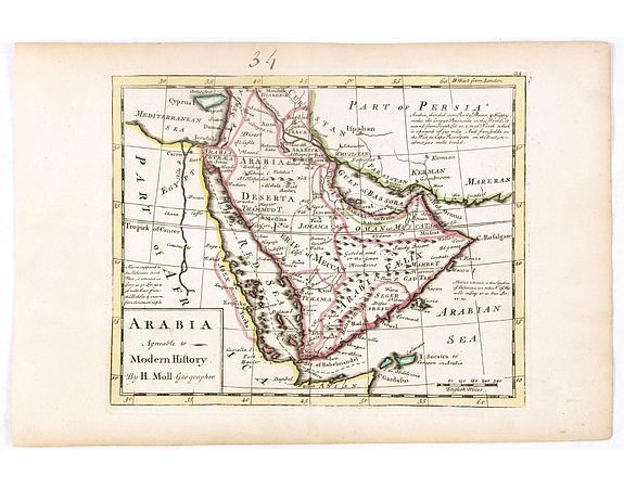
MOLL, H. - Arabia agreeable to Modern History.

Description
Detailed map of the Arabian Peninsula from the Mediterranean Sea to the Arabian Sea, and western Iran. with an engaging text block in the upper right corner: "Arabia, divided into Rocky Desert, & Happy, make the largest Peninsula in the World ..."
Exceptionally detailed, despite its small size, it covers the Red Sea and part of East Africa, the Arabian Peninsula eastward to the Arabian Gulf (labeled Gulf of Bassora), and northward to present-day Syria, Iraq, and Iran. There are two islands in the Gulf, one is labeled "Bahara I". The nearby mainland is marked BAHARA.
The map shows physical features, settlements, caravan routes, and tribal affiliation. Scale is indicated in miles. The Arabian Peninsula shows Latin terms Arabia Felix, Arabia Deserta, and Arabia Petraea. A trade route between Mecca and Bassora is shown on the map.
The name "Gulph of Bassora" for the Persian Gulf is noteworthy on this map. More traditional maps of the area, particularly maps created by Islamic cartographers, typically named the Gulf after Persia and had done so for a significant amount of time.
This naming is due to the commercial importance of Basra, located in Iraq at the head of the Persian Gulf, in establishing trade routes between Europe and the East.
In the Gulf of Bassora,we find names as Bahara Island (Bahrain) and Oman, Sohar, Iulphar, El-Catif and Catima in what would become the United Arab Emirates. “Oman or Muscat” is used to refer to the entire area of the Emirates and Oman, with the city of Muscat accurately placed.
Beyond the coasts, Mecca and Medina are given due importance, and accurately placed. A caravan route between Basra and Mecca is clearly delineated, shown meandering between water sources.
In about 1678, Herman Moll, a German, came to London and worked as an engraver for other publishers in the city. He soon set up his own business publishing atlases and also separate maps of all parts of the world. His work was varied, ranging from miniature maps to large very decorative wall maps.
Published in Moll's "Atlas Minor". The work was first issued in 1729.
- Reference N°: 37698
 Click on image to zoom
