Malta
The Silk Road extended approximately 6,437 kilometers (4,000 miles) across some of the world’s most formidable landscapes, including the Gobi Desert, the Pamir Mountains and traversed several of Uzbekistan’s major cities, including Samarkand, Bukhara and Khiva. The roads were typically in poor condition. Robbers were common. To protect themselves, traders joined together in caravans with camels or other pack animals. Over time, large inns called caravanserais cropped up to house travelling merchants.
One of the most famous travelers of the Silk Road was Marco Polo (1254 C.E. –1324 C.E.). Born into a family of wealthy merchants in Venice, Italy, Marco traveled with his father to China (then Cathay) when he was just 17 years of age.
It is hard to overstate the importance of the Silk Road on history. Religion and ideas spread along the Silk Road just as fluidly as goods. Towns along the route grew into multicultural cities.
The exchange of information gave rise to new technologies and innovations that would change the world.
The below antique maps are available for immediate sale, they are sold with a certificate of authenticity and published at the date indicated in the catalog description.
One of the most famous travelers of the Silk Road was Marco Polo (1254 C.E. –1324 C.E.). Born into a family of wealthy merchants in Venice, Italy, Marco traveled with his father to China (then Cathay) when he was just 17 years of age.
It is hard to overstate the importance of the Silk Road on history. Religion and ideas spread along the Silk Road just as fluidly as goods. Towns along the route grew into multicultural cities.
The exchange of information gave rise to new technologies and innovations that would change the world.
Antique maps including the Silk Route region
The below antique maps are available for immediate sale, they are sold with a certificate of authenticity and published at the date indicated in the catalog description.
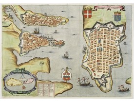
Location: 1565
Published: Rome, 1565
Size: 375 x 510mm.
Color: Uncolored
Condition:
The map includes a title cartouche with a lettered-key A-P and imprint at the top left and a scale decorated with a compass a..
4,000€
Location: 1629
Published: Paris, Michael Soly, 1629
Size: 386 x 535mm.
Color: Uncoloured.
Condition: In middle condition. A lot of tricks.
Early copper engraved map of the town of Valetta, engraved by Henry Raignauld. In lower left corner an inset with Malta and G..
3,000€
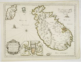
Location: 1667
Published: Paris, 1667
Size: 525 x 395mm.
Color: In original o/l colours.
Condition: In good condition. Good and dark impression. Some light marginal foxing, slightly affecting upper right hand part of the map.
Rare map of the islands of Malta, Gozo, Comino and Cominotto with fine title cartouche lower left. Inset plan of Valetta (110..
1,500€
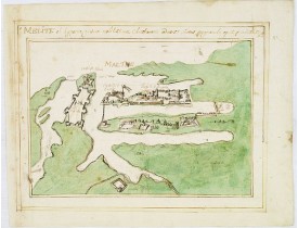
Location: 1700
Published: France, ca. 1670-1700
Size: 216 x 291mm.
Color: Uncoloured.
Condition: Original manuscript map in brown ink and green wash colour. Slightly stained, but altogether in very good condition.
Manuscript town-plan of Valetta on Malta, based on the engraving in Braun and Hogenberg' townbook from 1572-1624.A schematic ..
1,500€
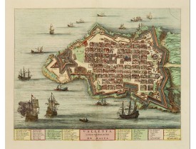
Location: 1705
Published: Amsterdam, 1705
Size: 400 x 505mm.
Color: Coloured.
Condition: A nice and attractive impression.
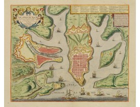
A beautifully engraved and richly detailed birds-eye plan of the harbour and city of Valletta seen from the northwest. In low..
3,000€
Location: 1723
Published: Paris, 1723
Size: 155 x 288mm.
Color: In attractive full colour.
Condition: Paper very minor age toned.
Detailed plan of Valetta. In upper right corner a key to the principal places in town. Prepared by N.de Fer and re-issued by..
2,200€
Location: 1751
Published: Paris, 1751
Size: 580 x 895mm.
Color: Uncolored
Condition: Paper age toned, split along center fold. Small part in lower left corner missing. Backed on card board.
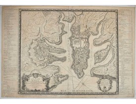
First edition of this attractive large scale plan of Valetta on Malta. To the left and right a numbered key 1 - 269. In lower..
3,700€
Location: 1761
Published: Bova Ant., Palermo, 1761
Size: 300 x 425mm.
Color: Uncoloured.
Condition: Several folds as issued, with paper thinness on crossings. Upper margin cut till plate mark and some minor tears.
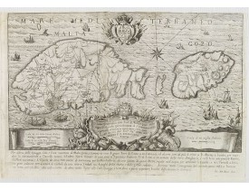
A rare map of Malta and Gozo printed by the priest Antonio Bova (1688 - 1775), who was active as engraver in Palermo ca. 1727..
1,900€
Showing 1 to 8 of 8 (1 Pages)


