
JOLLAIN, F. - Composite Atlas.
 Click on image to zoom

Description
The atlas includes several scarce maps, not only of America but also of the world, the continents, Switzerland, France, England, Flanders, Ukraine… indeed some of the maps are only known in a few copies.
The cartographers and publishers present in the atlas are as follows : Gérard I Jollain, Louis de Mayerne Turquet, Jean Boisseau, d’Avity, C. Savary & B. Gaultier, Nicolas Berey, Nicolas Langlois, le Père Claude Bonjour, Michel van Lochom, Jacques Lagniet, Jean Leclerc, Christophe Tassin, Pierre Mariette, Nicolas de Fer and indirectly Jacques Honervogt, whilst not forgetting the Dutch
cartographers: J. Hondius, Visscher, J. Janssonius and Blaeu, who all enabled Jollain to compose the atlas.
377 x 555 mm
Separate publication. The map closely copies Jodocus Hondius' world map of 1617, although some of the lively border details appear to have been taken in preference from Hondius’ later map of c. 1625. The eastern hemisphere retains the line of the Antarctic continent and does not show any of the Australian discoveries. Unlike Hondius' 1617 map (but following his later one), Honervogt shows a zodiacal line, curving to the south of the equator on the left (western) hemisphere and to the north of the equator on the right (eastern) hemisphere.
"Examples of the map are rare and I have only seen one with the date 1625 and two of a later state by Jollain dated 1655" (Shirley).
This rare world map was first published by Jacques Honervogt (c.1590-c.1663) who was a native of Cologne and worked from 1608 as an engraver in Paris. After 1654 he worked with Gérard Jollain. Around 1663, Gérard Jollain bought from Honervogt the house "a la Ville de Cologne".
The name of Honervogt has been erased but is still visible under the name of Jollain.
Shirley, The Mapping of the world, 315. Library of Congress Control Number 2002622159.
 VISSCHER, N/ HONERVOGT, J. / JOLLAIN, G.
Homogeneous set of continental maps in third state.
Extremely rare maps separately published, first by J. Honervogt, here with the imprint of Gérard Jollain.
The America is a version of the Visscher issue of the van den Keere of America, 1614. However Honervogt does not include any decorative borders and alters the cartouche. State 3 with the imprint of Jollain.
The Africa is modeled after Pieter van den Keere 1614 map in its third state of 1636, as issued by Claes Jansz. Visscher. Honervogt's re-issue does not include the decorative borders. Burden, The mapping of North America, 259. Betz, The mapping of Africa, 70.3.
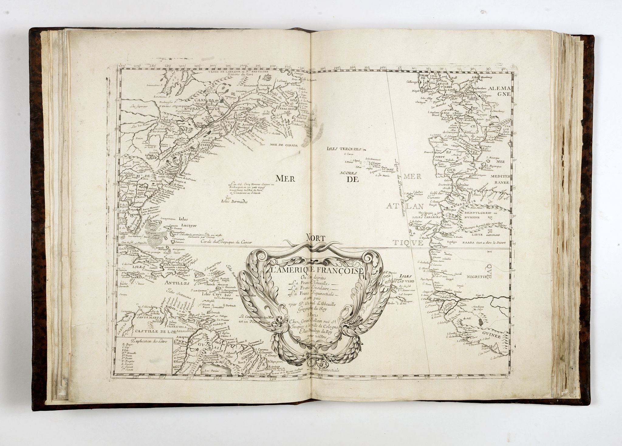 DUVAL, Pierre / JOLLAIN, Gérard. L'Amérique françoise où son Décrites La France nouvelle… et autres païs / par P. Duval, …
Paris, Chez Gerard Jollain rüe St. Jacques a la ville de Cologne Avec Privilege du Roy pour 20 Ans, ca. 1665.
Separately published. The scarce map is only recorded in Burden’s Appendix 1.
The map is undated and appears to derive from more than one source. It generally draws upon the Nicolas Sanson model of North America, first published in 1650. This is most noticeable with its depiction of the Carolina coastline, which had been updated on Sanson’s le Canada, ou Nouvelle France, 1656, and used on other later Parisian publications. However, the nomenclature originates from various slightly later French sources.
Despite the cartographic evidence placing the map as early as the late 1650s, the author (Burden) assigns a date of c.1665 based on other factors. Gérard Jollain started publishing in partnership with Jacques Honervogt in approximately 1654. However he did not take control until the death of Honervogt c. 1663. An unconfirmed second state was described in 1909 by Diome; its location is not recorded.
Only three examples are known: NYPL, BN Paris and Private German Collection.
Burden, The Mapping of North America, 382a.
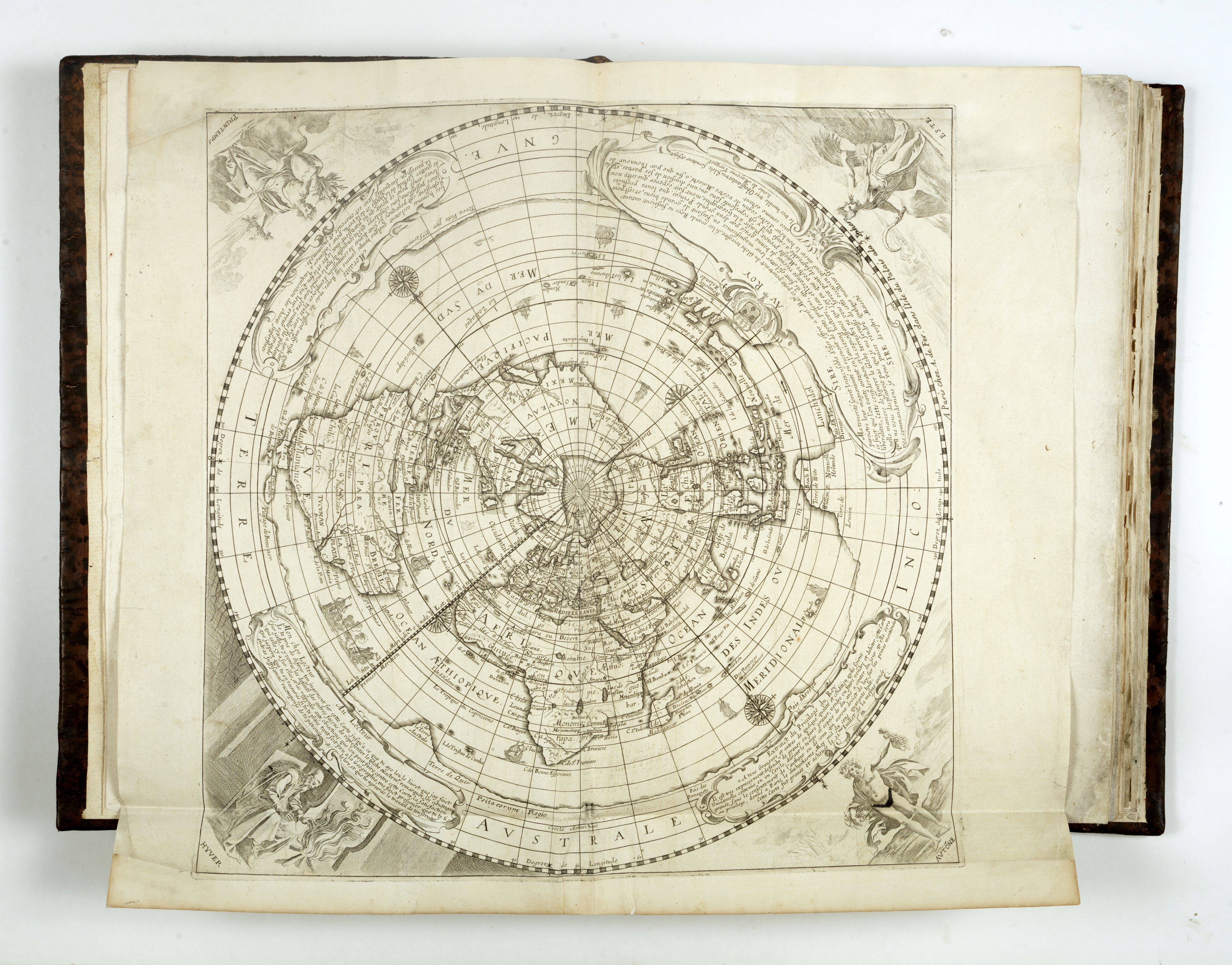 DE MAYERNE TURQUET, Louis. [La Nouvelle manière de representer le Globe terrestre . . . Inventée par Louis de Mayerne Turquet]. Edition without title.
Paris dans l’Isle du Palais Antoine de Fer, 1648
(1661)
DE MAYERNE TURQUET, Louis. [La Nouvelle manière de representer le Globe terrestre . . . Inventée par Louis de Mayerne Turquet]. Edition without title.
Paris dans l’Isle du Palais Antoine de Fer, 1648
(1661)
Rare map of the world on a north polar Postel azimuthal projection with equidistant concentric circles of latitude. (A similar edition is in the collection of the BnF).
The present example is the 1661 edition of the map, with the original title erased (although still visible to the lower part of the map) and the addition of Antoine de Fer’s imprint.
The map was first published in Louis de Mayerne Turquet's Discourse Sur la Carte Universelle…, published in Paris in 1648. In the book, Mayerne Turquet details numerous map projections, including projections by Gemma Frisius, Peter Kaerius, Abraham Ortelius and Guillaume Postel, among others. The map illustrates a projection that is his own invention, which Mayerne Turquet published as an attachment to Discourse.
While the two editions of the map appear similar, there are a number of differences. In the first edition, the allegorical depictions of the four seasons are unnamed. In the second edition, each is named. The printer's address appears only on the first edition, near the top center of the map, whereas the second edition shows De Fer's name in the lower left section. The second edition adds a number of place names and new islands not shown on the first edition. The lower left cartouche is re-engraved in the second edition, and includes a different coat of arms.
Of perhaps greatest cartographic note, it is the second edition of this map that first includes the name "Nouvelle Hollande" in the Southern Continent, where only the name Beach appeared in the first edition. Other names added by Mayerne Turquette including Pais d' A Van Diemen, Terre de Wits, Willem R. and Terre de Leuwin, demonstrating that he was aware of the then current theory that Australia may have first been discovered by a Frenchman, Captain Binot Paulmyer de Gonneville, in 1504. This story had gained significant currency in the mid 17th Century in France and influenced the cartography of French Mapmakers for the next 100 years.
Mayerne Turquet’s map shows the entire world in one circle, with inevitable distortions to the areas at the extreme radii. The geographical outline is simplified, with the borders of various countries shown, but only a few place names. Around the map are panels of text and personifications of the seasons. As Eyries states in Nouvelles Annales, II, “La projection en est très bizarre.” - The map is truly bizarre.
To produce a map of the world in a convenient way, cartographers use map projections: any transformation between the curved reference surface of the earth and the flat plane of the map. The transformation from the curved reference surface of the earth to the flat plane of the map is never completely successful. By flattening the curved surface of the sphere onto the map the curved surface is stretched in a non-uniform manner. The distortions increase as the distance from the central point of the projection increases. On a world map, the distortions are evident where landmasses are wrongly sized or out of shape and the meridians and parallels do not intersect at right angles or are not spaced uniformly.
The five common azimuthal (also known as Zenithal) projections are the Stereographic projection, the Orthographic projection, the Lambert azimuthal equal-area projection, the Gnomonic projection and the azimuthal equidistant or Postel projection, so named after Guillaume Postel’s 1581 northern hemisphere map. The Postel projection style would become the standard for polar terrestrial maps for centuries.
The first cartographer to fashion a north polar azimuthal equidistant map of the entire world was Urbano Monte of Milan. Monte’s map consited of sixty-four sheets and was issued in 1603. Mayerne Turquet’s work followed in 1648 and inspired others, including the highly influential work of Jean-Dominique Cassini, who produced a now lost world map on the floor of the Paris Observatory in the 1680s.
References: Shirley 375. Margaret Sankey, The French and Terra Australis.
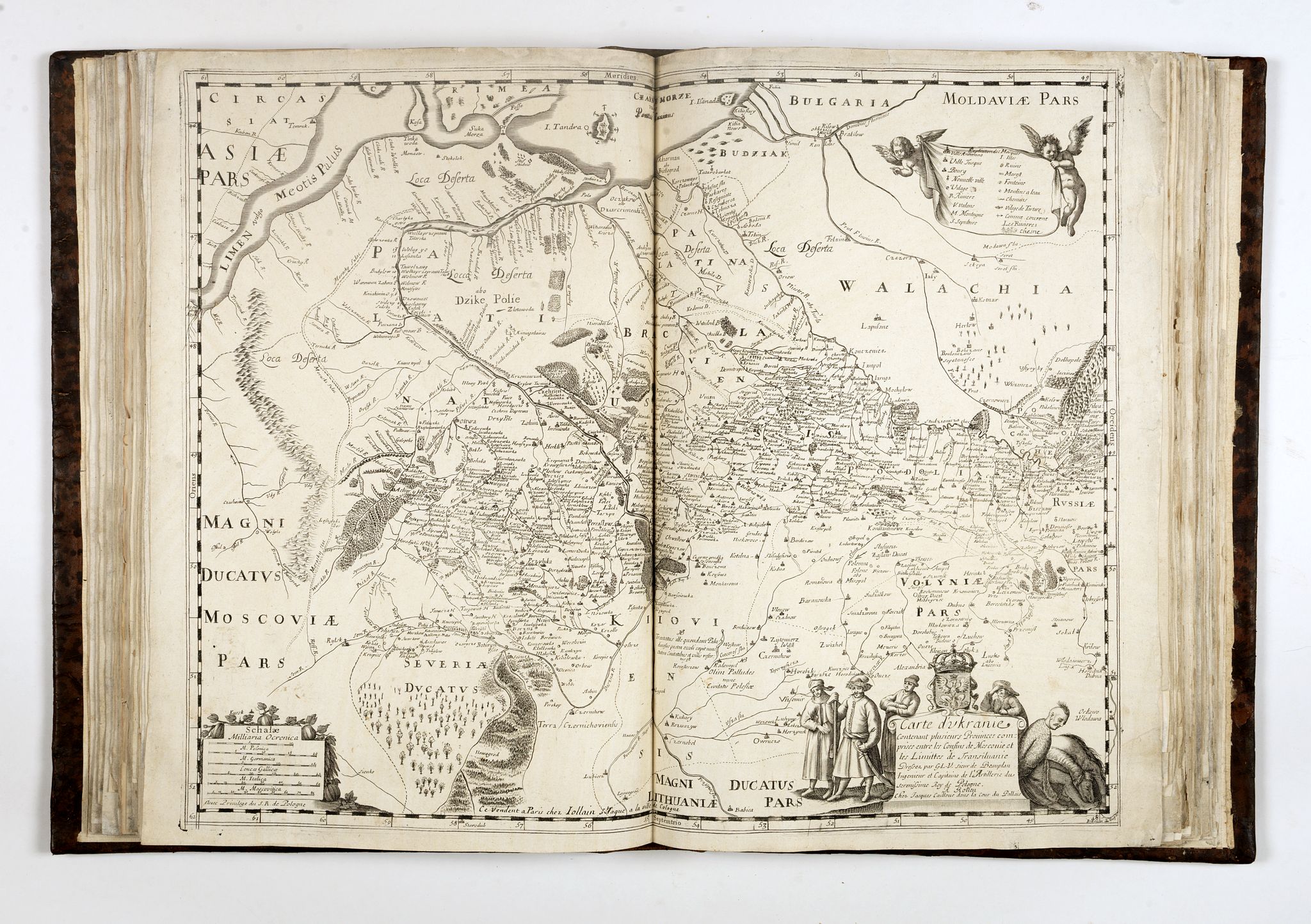 JOLLAIN. Carte d'Ukranie Contenant plusieurs Provinces comprises entre les Confins de Moscovie et les Limittes de Transilvanie [Document cartographique] / Dressez par G.L.V. Sieur de Beauplan, Ingénieur et Capitaine de l'Artillerie du sérénissime Roy de Pologne. A Rouen : Chez Jacques Cailloue ; Ce vendent a Paris chez Iollain, St. Jacques à la ville de Cologne. Ca. 1660.
Second known copy of the first state without date.
The map created by Beauplan in 1648 was engraved by Willem Hondius and first published in Rouen, in 1651, in the extremely rare edition of Description d'Ukranie , and re-published in 1661.
Gérard I Jollain should have bought the plate and re-published the map with his imprint “Ce vendent a Paris chez Iollain, St. Iacque à la ville de Cologne”.
A second state is known with the address "à l'Enfant Iesus. 1686", probably published by Gérard II Jollain (son of Gérard I), who took over the address “à l’Enfant Iesus”. (one copy known in the BnF).
“Guillaume Levasseur de Beauplan (c. 1600 – 6 December 1673) or William le Vasseur de Beauplan was a French-Polish cartographer, engineer and architect.
Beauplan served as artillerycaptain for the army of the Crown of the Kingdom of Poland between 1630 and 1647 or 1648. He was sent to Ukraine where he served under Stanisław Koniecpolski in 1637–38. He used his architectural skills while in the military. In 1639, he was involved in the rebuilding of the Kodak Fortress. He also built a fortress at Bar, worked on Brody Castle, and structures in Kremenchuk.
In 1639, Beauplan created the first "descriptive" map of Ukraine. He created a map of Ukraine in 1648 that had detailed border information. By 1654 he was working in Danzig. He created a map with a scale of 1:452,000 and an additional map scaled at 1:1,800,000. Both maps were engraved by Willem Hondius. These maps would go on to be published in Rouen, France. Beauplan published another map of the Dnieper River in 1662.
He wrote Description des contrés du Royaume de Pologne, which was published in 1651. It was renamed Description d'Ukranie, when the second edition was released in 1651. Two more editions were published in 1660 and 1861. The book was the first book published that provided a geographical, economic, and demographic description of Ukraine. By 1832 it had been translated into five languages.”
Second exemplaire connu de ce premier état non daté.
Orientée au Sud. Cartouche de titre aux armes de la Pologne, décoré de personnage en bas à droite. Dans un cartouche figurant une draperie présentée par des Amours, en haut à droite, la légende des signes. Cartouche d’échelle orné en bas à gauche.
Beauplan, Guillaume Le Vasseur (16..-1673 ; sieur de), Ingénieur militaire et cartographe normand.
Probablement fils de Guillaume Le Vasseur, il naquit à Dieppe à la fin du 16e s. Etudia la science nautique et fit quelques voyages au long cours. Mais ses préférences allèrent au métier des armes. Resta au service des rois de Pologne de 1632 à 1648 et prit part aux campagnes de l'Ukraine. Dressa une carte de Pologne et plusieurs cartes particulières. A son retour en France en 1648 rédigea une Description de l'Ukranie. En 1650 devint "sergeant major" de Dieppe. En 1651 publia un Traité de la sphère et de ses parties et en 1662 des Tables des déclinaisons du soleil. Ingénieur ordinaire du Roi.
References: 1 exemplaire recensé à la BnF, cote GE AF PF-18(80)
BOISSEAU, J.
Pastoureau, Boisseau II. Theatre des Gaules,[4] ; Betz, The mapping of Africa, 66.1. (see image)

Pastoureau, Boisseau II. Theatre des Gaules, [5] ; Burden, The mapping of North America, 249
Maps separately published, c. 1636 or in Theatre des Gaules, 1642. I t is possible that the maps were issued in partnership with Alexandre de Meufves, whose name can be seen erased from both the Asia and Africa maps. Jean Boisseau’s name itself is not present on the America map, just the engraver’s Hugues Picart, and the original author of the map after whom this is drawn, Jodocus Hondius.
Boisseau, who styles himself “Enlumineur du Roy”, was very active in the French map market in the 1630s and 1640s. The maps accompanied this the last edition of Maurice Bouguereau’s le Theatre François, the first national atlas of France, under the new title of Theatre des Gaules.
ANONYMOUS / D’AVITY. [CARTES A FIGURES]
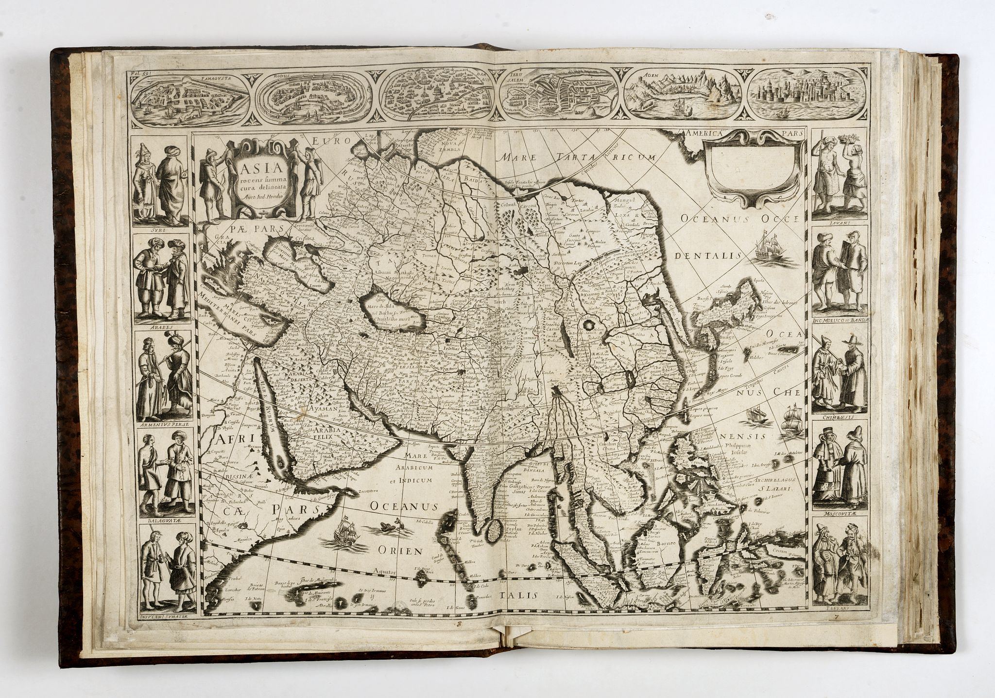
Top left pagination Fol. 59
The map shows birds-eye views of Famagusta, Rodus, Jersulem, Aden and Ormus across the top, and 10 sets of costumed figures of Syrians, Arabs, Armenians, Balguates, Sumatrans, Javans, Moluccas and Bandas, Chinese, Moscovite and Tartar figures. Corea is shown as a peninsula, with an odd projection of Japan.
Très rare et belle carte à bordures de l'Asie publiée dans l'ouvrage de Pierre d'Avity Les Estats empires royaumes et principautez du monde, Lyon 1659. Elle est ornée de six vues de villes à vol d'oiseau (Famagouste sur l'île de Chypre, Rhodes, Damas, Jérusalem, Aden et Ormuz) et de dix vignettes figurant des habitants du continent en costumes traditionnels (Syriens, Perses, habitants de Sumatra, Javanais, Chinois, Moscovites…). L'océan est décoré de quatre vaisseaux. Cette carte fut gravée et publiée par Nicolas Picart. Le premier état date de 1644. Sur le second ici présent, le cartouche en haut à droite contenant le nom de Picart a été laissé vide. Petit manque à la dernière vignette en bas à gauche, très bonne condition générale. Schilder, VI, App. Map 14.2.
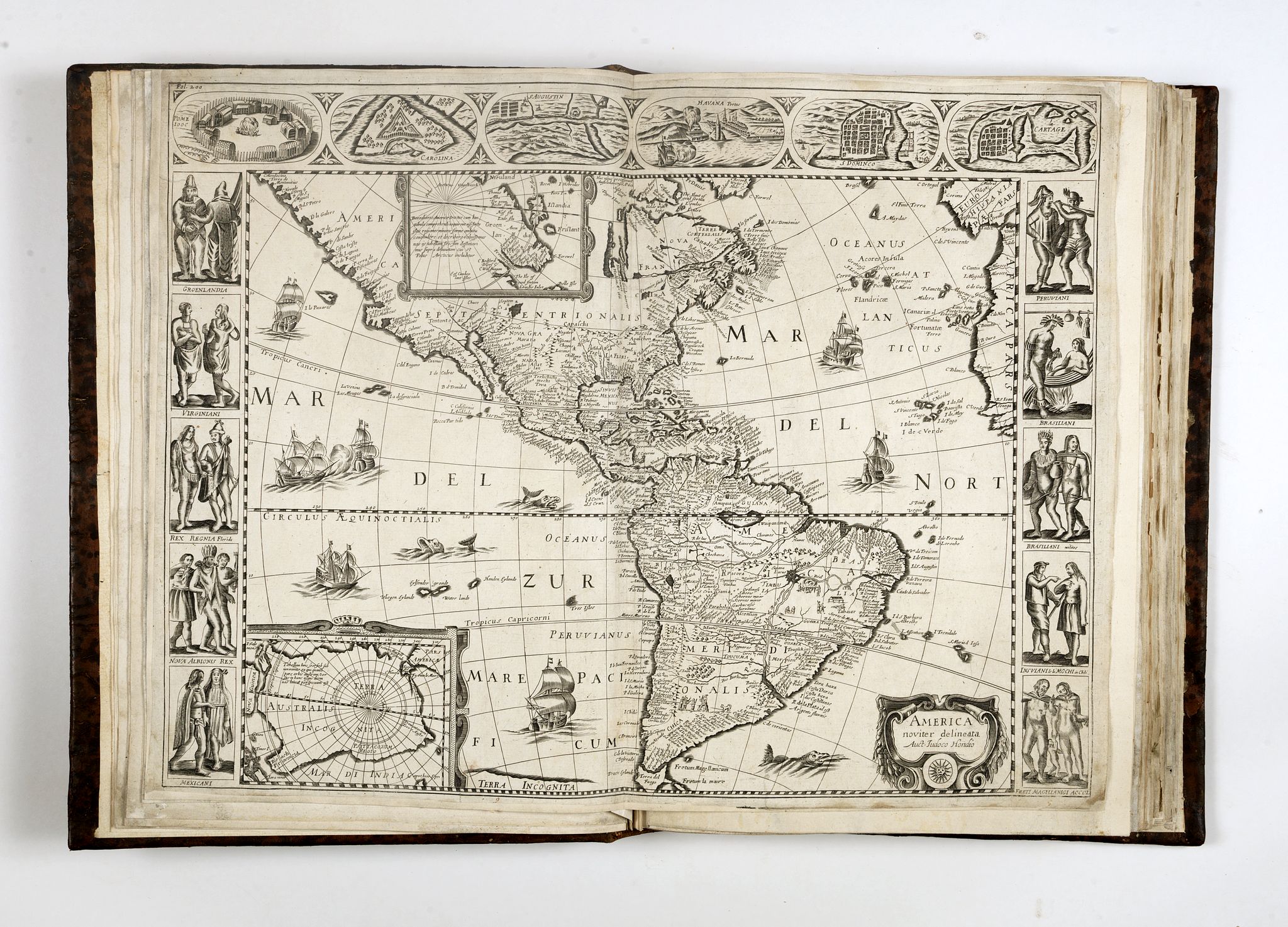 America noviter delineata. Auct. Judoco Hondio ?
Top left pagination Fol. 200
These very rare panelled maps appear in an edition of Pierre D’Avity’s Etats, Empires, Royaumes… du Monde, Paris, 1659.
The America map is drawn from the Picart of 1644, itself derived from the second state of the Janssonius 1623, after the lower border has been removed. The most noticeable difference is the removal of the two skulls below the cartouche. Both the Picart and this one were thought to have been from the same plate ; however, closer examination reveals otherwise. Apart from the lack of any other imprint than that of Hondius, there are numerous typographical differences. The plan of Cartagena above right becomes Cartage, and the longitudinal markers on the Equator are not numbered in South America. It is one of the few printed maps of America with decorative borders. Unlike the Blaeu of 1617, which had only South American views above the map, three views here are of North American towns. These are Pomeiooc, an Indian village in Virginia, the French fort Carolina and S.Augustin in Florida.
Burden, The Mapping of America, 333.
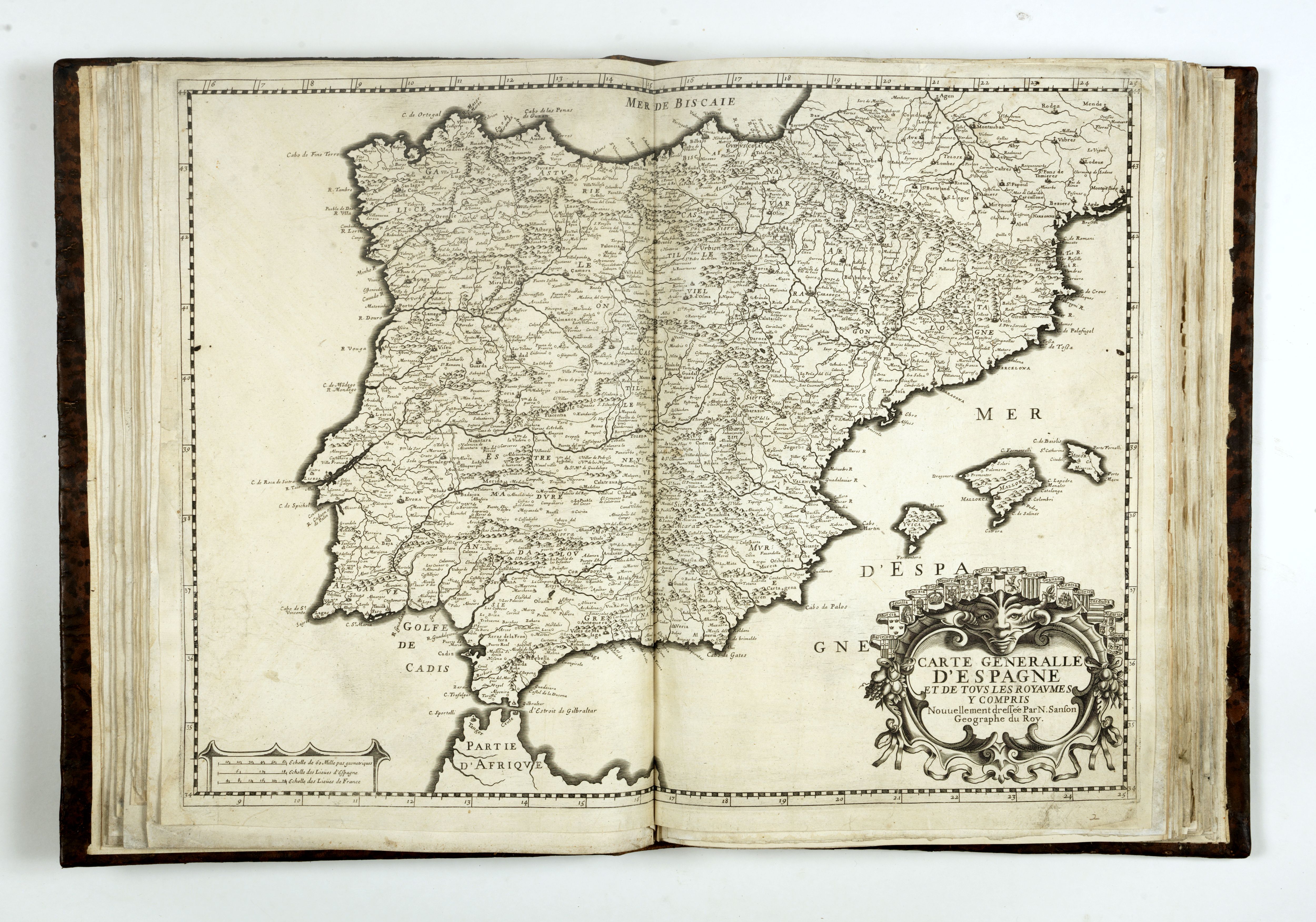 JOLLAIN, Gérard. Carte Generale d' Hespagne . A Paris Chez Gerard Iollain demerant Rue Sainct Iacques, a la Ville de Colloigne, ca. 1665.
Very rare map of the Iberian Peninsula with the Balearic Islands.
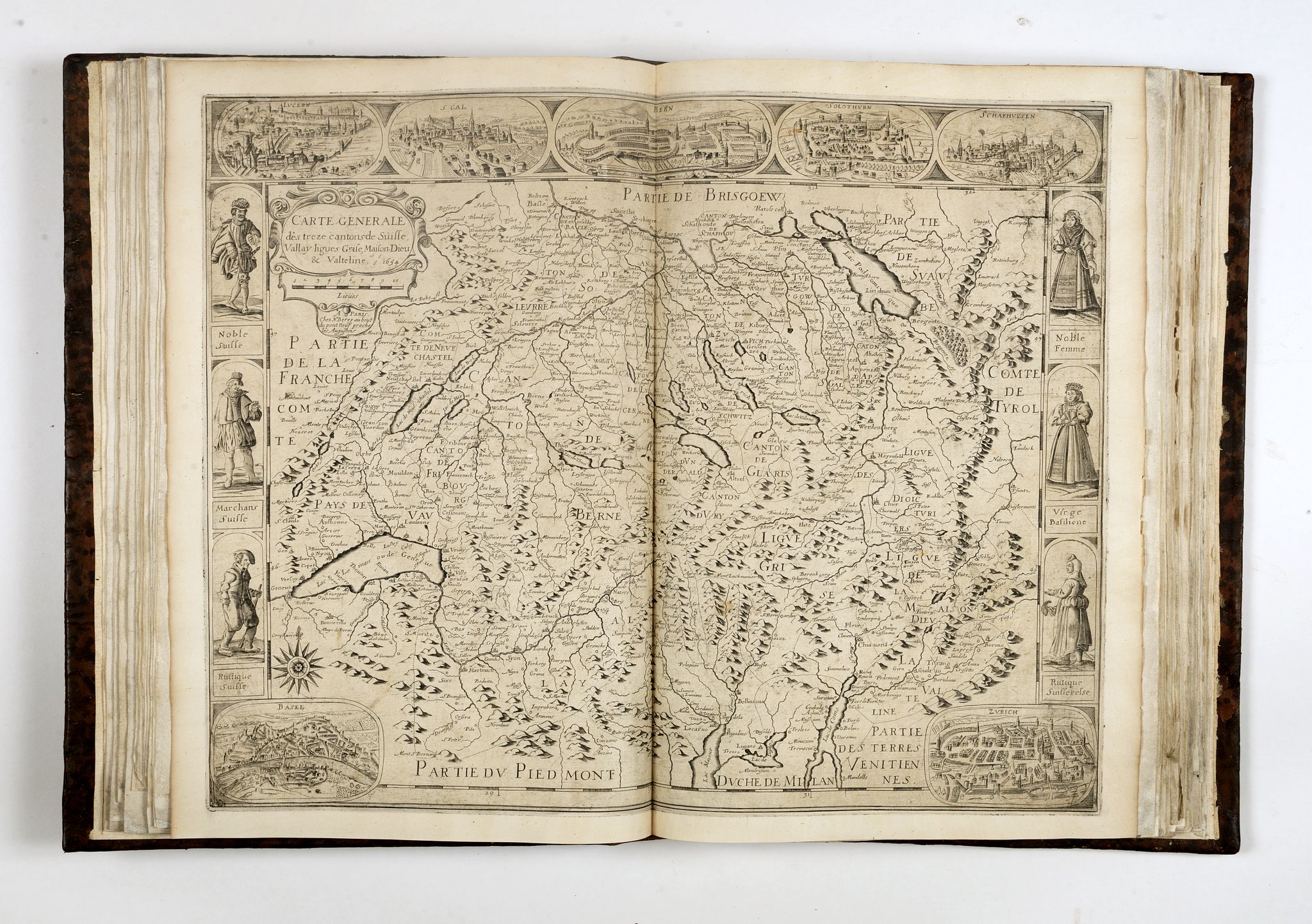 Schweiz. Berey 1654
Schweiz. "Carte generale des treze cantons de Suisse, Vallay ligues Grise, Maison-Dieu & Valteline". Kupf.-Kte. Von N. Berey, Paris, 1654. Mit ornament. Kart., Windrose u. 3 Bildleisten. 41:53 cm. Schilder/Stopp, MCN VI, App. 24.1 (von 2); Blumer 112; Guidicetti S. 7. - Seltene Erstausgabe, es folgte nur eine weitere Ausg. Mit geänderter Adresse bei N. Langlois 1670. "Copied… faithfully from the Jodocus Hondius map… The spelling of the names of the towns is also the same… The geographical names on the map itself, given in Latin or German on the original, are translated into French" (MCN). Mit den Ansichten von Luzern, St. Gallen, Bern, Solothurn u. Schaffhausen oben sowie in den Unterecken Basel u. Zürich, ferner seitl. Je 3 weibl. U. männl. Trachtenfiguren.
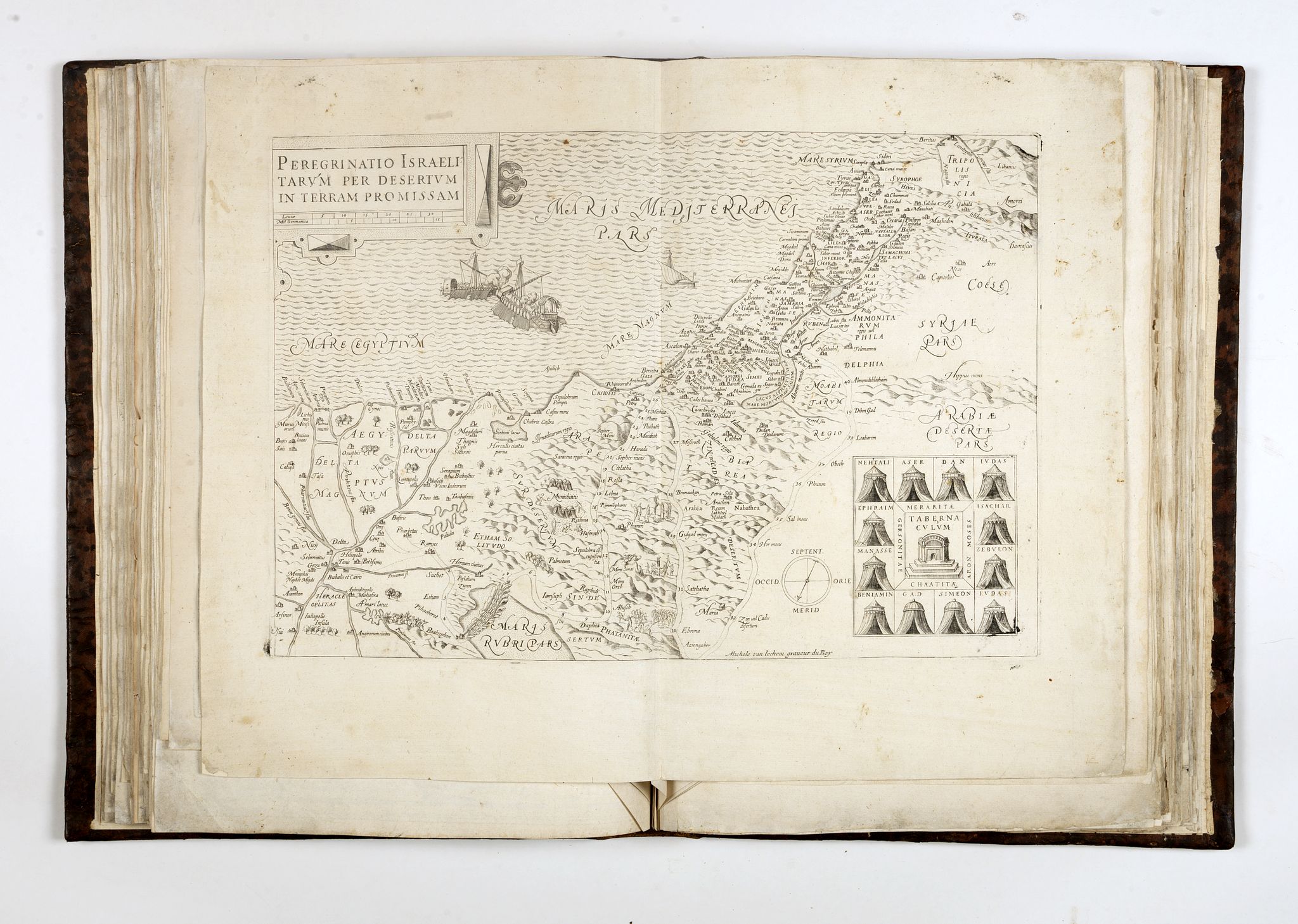 VAN LOCHOM, Michel. Peregrinatio Israelitarum per desertum in Terram Promissam. [S.l.], [s.n.], ca 1641.
Rare map depicting the Wandering of the Jews through the desert into the Promises Land, with their 42 Stations.
A late re-engraving of Ortelius “Palestine” after Tilemannus Stella, engraved by Michael Van Lochom, a Flemish engraver who worked in Paris as royal engraver.
Michel Van Lochom (Anvers, 1601-Paris, 1647).
M. Van Lochom était établi à Paris rue St. Jacques, à l’enseigne de la Rose Blanche Couronnée, dès 1635. Il n’a pas publié d’atlas, mais un certain nombre de cartes isolées.
Laor, Maps of the Holy Land, 446.
The atlas does contain a hand written index listing 109 maps. Each individual map is numbered on the verso in same hand in brown ink. The following maps are not bound in the atlas : 21, 28 51 54 55 56 57 58 59 60 61 62 63 95 96 97 98 99 100. The atlas contains therefor 89 maps and an hand written index page.
The following maps are included in the atlas
Contents of the atlas.
1. HONDIUS, Jodocus Jnr / HONERVOGT, J. / JOLLAIN, G. - Nova Totius Terrarum Orbis geographica ac hydrographica tabula. 1655. Shirley, The Mapping of the world, 315
2. DE MAYERNE TURQUET, Louis / A. DE FER – [La Nouvelle manière de representer le Globe terrestre . . . Inventée par Louis de Mayerne Turquet]. [1648 (1661)]. Shirley 375.
3. JOLLAIN - Nova Europae descriptio auctore Visscher Jollain exc. 1658
4. JOLLAIN – Nova Asiae descriptio auctore Jollain excud. 1667
5. JOLLAIN - Nova Africae per Nicolaunlo Visscher Jollain excudit 1666. (See Betz, The mapping of Africa,70.3)
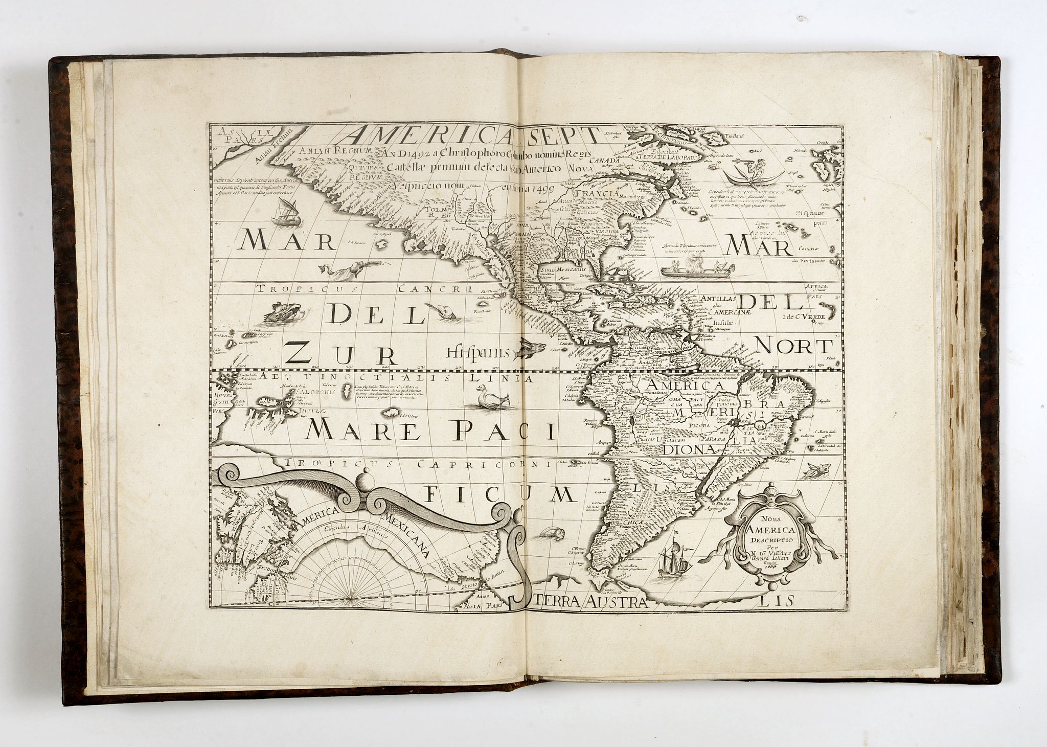
6. JOLLAIN – Nova America descriptio per N. lo Visscher Gerard Jollain excudit 1666.
3rd state with address of Jollain. (See : Burden, The mapping of North America, 259.)
7. HONDIUS/ BOISSEAU - Africae nova tabula auct Jud Hondio
8. HONDIUS/ D’AVITY – Asia Recens summa Cuma delineate auct: Jud: Hondio
9. HONDIUS/ D’AVITY – America noviter delineate auct: Judoco Hondio. (See : Burden, The mapping of North America, 249.)
10. JANSONNIUS – Americae pars meridionalis
11. HONDIUS/ BOISSEAU – America noviter delineata auct: Judoco Hondio
12. DUVAL / JOLLAIN - L’Amerique Françoise … Chez Gerard Jollain. (See : Burden, The Mapping of North America, 382a.)
13. JANSONNIUS – Insulae Americanae in oceano septentrionali, …
14. JANSONNIUS – Peru
15. JANSONNIUS – Chili
16. JANSONNIUS - Freti magelanici ac novi freti vulgo LE MAIRE
17. JANSONNIUS - Virginiae partis australis, et Floridae partis… nova descriptio
18. HONDIUS/ JANSONNIUS – Nova Virginiae tabula
19. HONDIUS/ JANSONNIUS – Ins Ceilan que incolis tenarisin dicitur
20. JANSONNIUS – Paraguay, O prov, de Rio de la plata…
21. JANSONNIUS – Galliae veteris typus
22. SAVARY/GAULTHIER – Gallia – Nova Galliae descriptio multis in locis de integro emendata / C. Savary et B. Gaulthier excudit 1627. (Only one other copy known in BnF.)
23. DE FER, N. – La France ecclesiastique contenant les Archeueschez et Eueschez de ce
Royaume avec leurs noms tant anciens que modernes. 1674.
24. JOLLAIN, Gerard – Carte générale de l’Hespagne
25. SANSON, N. – Carte généralle d’Espagne et de tous les royaumes y compris
26. JOLLAIN – Carte d’Italie Corsique Sardegne et Royaumes sircumvoysines. Jollain excudit 1667
27. BEREY – Carte generale des treze cantons de Suisse, Vallay ligues Grise, Maisons-Dieu & Valteline 1654. (First edition. See : Schilder/Stopp, MCN VI, App. 24.1 (of 2)
28. LANGLOIS, N. – Charte de la Suisse de la Rhetie, ou des Grisons, de la Valteline, du Valay, et
autres Seigneuries […] 1665
29. MERCATOR/JANSSONIUS – Das Wiflispurgergow
30. HONDIUS/JANSSONIUS – Comitatus Glatz authore Iona Scultero. Henricus Hondius excudit
31. MERCATOR/JANSSONIUS – Argow cum parte merid. Zurich Gow
32. JANSONNIUS – Zurichgow et Basiliensis provincia
33. BONJOUR, C. – carte geographique de la souveraineté de Neu Chatel et Vallangin
34. JOLLAIN – Description du pays Genvois et Des lieux circonvoisins Lacus Lemani […] 1663.
(Only one other copy known is in the Bibliothèque de Genève and is dated 1686. Our example has the address chez Jollain rue S. Iacques a Lenfant Jesus » and is undated.)
35. JOLLAIN – [Belgique-Pays-Bas] Sans titre – 1672
36. JANSONNIUS – Insularum Britannicarum acurata delineatio ex geographicis conatibus Abraham Ortelii
37. JOLLAIN – L’Angleterre / Novissima descriptio Angliae, Scotiae et Hiberniae.
Shirley, Early printed maps of the British Isles 1477-1650 : 664.
38. JANSONNIUS – Regni Daniae accuratissima delineatio
39. JANSONNIUS – Moscoviae pars australis auctore Isaaco Massa
40. JANSONNIUS – Russiae vulgo Moscovia dictae, partes septentrionalis et orientalis
41. LANGLOIS, N. – Carte de Pologne et des états qui en dépendent
42. JOLLAIN – Carte d’Ukranie […]A Rouen chez Jacques Cailloue dans la Cour du Pallais. Ce vendent a Paris chez Jollain, St. Jacques à la ville de Cologne. (Undated and only one other example known in BnF.)
43. MERCATOR/HONDIUS - Taurica Chersones …
44. ORTELIUS/JANSSONIUS – Thraciae veteris typus ex conatibus geographicis Abrah Ortelii.
45. KAERIUS/JANSSONIUS – Vetus descriptio Daciarum nec non Moesiarum …
46. VAN LONCHOM, M. – Peregrinatio Israelitarum per desertum in terram promissam. (See : Laor, Maps of the Holy Land, 446.)
47. JANSONNIUS – Indiae orientalis nova descriptio
48. JANSONNIUS – Insularum Moluccarum nova descriptio
49. LECLERC, J. - L’Isle de France et lieux cincovoysins
50. BEREY, N. – Carte generalle du gouvernement de la Beausse avec ses confins […] 1653
51. TASSIN – Carte de Touraine
52. JOLLAIN – La Touraine, Turonensis Ducatus (1667)
53. LE CLERC, J. – Topographia aug. Turon Ducatus et confinium Galliae Celticae … 1592.
54. JANSONNIUS – Gastinois et Senonois
55. BOISSEAU, J. – Carte du Gastinois et Senonois. 1644
56. JANSONNIUS – Beauvaisis Comitatus Belovacium
57. LE CLERC – Description du Beawaisis
58. LE CLERC – Poictou
59. JANSONNIUS – Pictaviae ducatus descriptio, vulgo Le pais de Poictou
60. L’AGNIET, J. – Carte du païs et duché de Nivernois 1642/1666
61. LANGLOIS – Carte du gouvernement du haut et bas Lymosin
62. SAMSON /JANSSONIUS – La Saintonge uers le Septentrion, Le pays d’Aulnis et les Isles de Ré et Oleron
63. SAMSON / JANSSONIUS – La Saintonge vers le Midy : auecq Le Brovageais, terre d’Arvert &c
64. JANSONNIUS – Insulae divi Martini et Viliarus vulgo l’Isle de Ré et Oleron
65. JANSONNIUS – Description du Guienne
66. DU VAL / LANGLOIS, N. – La Guienne, Medoc, Saintonge, Aunis et païs voisins avec les Isles de Ré, et Oleron par DuVal d’Abbeuille geographe ordinaire du Roy
67. DU VAL /LANGLOIS – Coste de Gascogne. 1653. H.Picart fecit
68. LECLERC, J. /BOISSEAU ?– La carte du Bourdelois du pays de Medoc et de la Prevosté de Born
69. MARIETTE, P. – Carte du Querci
70. DU VAL, P. – La cartes des Eaux de la Montagne Noire […] Nouveau canal de Languedoc […] 1666
71. TASSIN – Carte de Provence
72. MARIETTE, P. – Carte du Bourdelois du pais de Medoc et de la Prevosté de Born / Carte de la principauté de Bearn
73. BOISSEAU, J. – Carte du Siege Presidial Dax […] 1638
74. LE CLERC, J. – Carte du pais d’Aunis ville et gowernement de la Rochelle. 1621. Picquet faciebat. (With text in 2 colomns on verso).
75. TASSIN – Carte generale de Guyenne
76. JOLLAIN /BLAEU – Britannia ducatus – Duche de Bretaigne . 1666. (Third state)
77. JOLLAIN – Normandia ducatus
78. JANSONNIUS – Descirptio Boloniae Pontieu comit S. Pauli cum adjacentibus
79. JOLLAIN – Artesiae comitatus L’Artois. Jollain Excudit 1666
80. JOLLAIN – La Picardie, Picardia vera et inferior Jollain excudit 1667
81. BLAEU - Perchensis Comitatus. La Perche Comte – Comitatus Blesensis Auctore Ioanne Temporio, Blaisois
82. JANSONNIUS – Archiepiscopatus Cameracensis, Archeveche de Cambray
83. LANGLOIS, N. – Carte generale de Picardie et Artois
84. LANGLOIS, N. – Carte d’Auvergne 1643
85. LANGLOIS, N. – Carte du Lionnois Forest et Bavielois
86. JOLLAIN – Description du Pais de Bresse. 1666
87. JANSONNIUS – Le Duche d’Aiguillon
88. LANGLOIS – Carte du gouvernement de Languedoc
89. JANSONNIUS – Le Diocese de Sarlat, Diocesis Sarlatensis
90. JANSONNIUS - Italia Gallica sive Gallia Cisalpina. Petrus Kaerius Caelavit.
(91) Manuscript index.
- Reference N°: 40348