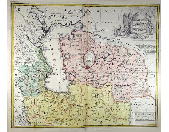
HOMANN HEIRS. - Nova Maris Caspii et Regionis Usbeck cum Provincijs adjacentibus vera Delineatio
 Click on image to zoom

Out Of Stock
HOMANN HEIRS. - Nova Maris Caspii et Regionis Usbeck cum Provincijs adjacentibus vera Delineatio
Published: Nuremberg, 1735
Size: 489 x 586mm.
Color: Original colors
Condition: Paper slightly age-toned.
Description
This is the first printed map specifically of the Uzbek region. The map shows the area around the Caspian Sea and northern Iran. The earea eastwards from the Caspian is marked 'UZBECK;' including modern-day Turkmenistan, Uzbekistan, Kyrgyzstan, Tajikistan and part of Kazakhstan.
A finely engraved, uncolored title piece showing costume figures decorates the map which identifies towns such as Astrakan, Eriwan, Isphahan, Samarkand, and Cabul, and, unusually, shows trade routes.
Oriented east to the top.
The map was prepared by Abraham Maas and edited by Johann Peter von Ghelen and published by Homann Heirs in 1735. Following Tsar Peter's 1723 annexation of the western coast of the Caspian Sea, an embassy was sent to Khiva, Bukhara and Balkh of which Abraham Maas is thought to have been included. The embassy produced a map published in Moscow that year, and submitted in a manuscript to the Tsar preserved the library of the Russian Academy of Sciences in St. Petersburg. Maas produced a faithful copy of that Russian map, translated to Latin. Von Ghelen's edition, committed to print here by Homann Heirs, presents for the first time indigenous toponymy east of the Caspian Sea. And indeed, Maas' map reveals a catalog of new place names: countries, administrative regions, deserts, seas, mountains, and towns which not previously known to western geographers. In addition, a network of roads between linking the Caspian to Kabul is shown.
The map is of interest as the Silk Road Route passing the area is included. The route starts in the west with Baghdad and the major route reaching east can be seen running to Isfahan, and ultimately Kandahar. Northern branches link Samarkhand, Kabul, and Kashgar.
The map is also of interest as it is one of the first maps to detail the Aral Sea: once a massive lake, now an infamous desert. It is one of the earliest maps to distinguish the Aral as separate from the Caspian. Running east-to-west are the Amu and the Syr rivers, both flowing into the Aral. An ancient diversion of the Amu from the Aral Sea into the Caspian can also be seen.
The map has rich detail and copious notations, forests, mountains, and wetlands are shown pictorially. The Caspian shoreline is marked with depth soundings. An attractive cartouche depicts three Uzbeks and a Streltsy - a Muscovite infantryman - situated in a vineyard. At the base of the cartouche are laid a scimitar, a bow and arrow, and bunches of grapes. One of the Uzbeks is seated, his shoes removed, leisurely smoking a shisha pipe.
800€
- See other items by this publisher: HOMANN HEIRS.
- Reference N°: 49117
