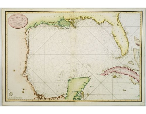
DÉPÔT GÉNÉRAL DE LA MARINE. - Carte des cotes du Golfe du Mexique..
 Click on image to zoom

DÉPÔT GÉNÉRAL DE LA MARINE. - Carte des cotes du Golfe du Mexique..
Published: Paris, 1800
Size: 598 x 893mm.
Color: Coloured.
Condition: Several wormholes filled in, hardly notable. Overall in very good condition.
Description
Detailed and important early chart of the Gulf Coast and Florida and dated 1800. From Neptune des cotes occidentales d'Amerique sur le Grand Ocean, an extensive atlas of charts of the western coasts of North and South America.
The chart was issued one year after the Spanish Carta Esferica and draws extensively from this map. This landmark mapping of Texas, Florida and the Gulf Coast, is based upon the 1799 Carta Esferica, the first large-scale printed chart of the Texas Coast based upon actual soundings and explorations.
The chart is based in large part on the landmark survey of the coast commissioned by Bernardo de Galvez and conducted by Jose de Evia. The most significant milestone of the survey was the discovery of Galveston Bay in 1785, which had never before appeared on a printed map. Baie de Calvesion (Galveston) is shown on the present map exactly as laid down in the manuscript maps from Evia's Survey.
The coastline configuration in the established the prototype for the mapping of Texas and the U.S. Gulf Coast which would dominated printed maps for the next 2 decades. The map remained as one of the most significant charts of the region for several decades. Both Humboldt and Arrowsmith copied the information set forth in this map for their important maps.
On the map it is noted Grave par E. Collin, et Ecrit par Besancon, Etienne Collin is also noted as being a engraver for 'Depot de la Marine'. It is probable that Collin engraved the map after originals by Besançon. ¤
The chart was issued one year after the Spanish Carta Esferica and draws extensively from this map. This landmark mapping of Texas, Florida and the Gulf Coast, is based upon the 1799 Carta Esferica, the first large-scale printed chart of the Texas Coast based upon actual soundings and explorations.
The chart is based in large part on the landmark survey of the coast commissioned by Bernardo de Galvez and conducted by Jose de Evia. The most significant milestone of the survey was the discovery of Galveston Bay in 1785, which had never before appeared on a printed map. Baie de Calvesion (Galveston) is shown on the present map exactly as laid down in the manuscript maps from Evia's Survey.
The coastline configuration in the
On the map it is noted Grave par E. Collin, et Ecrit par Besancon, Etienne Collin is also noted as being a engraver for 'Depot de la Marine'. It is probable that Collin engraved the map after originals by Besançon. ¤
4,000€
- Reference N°: 25159
