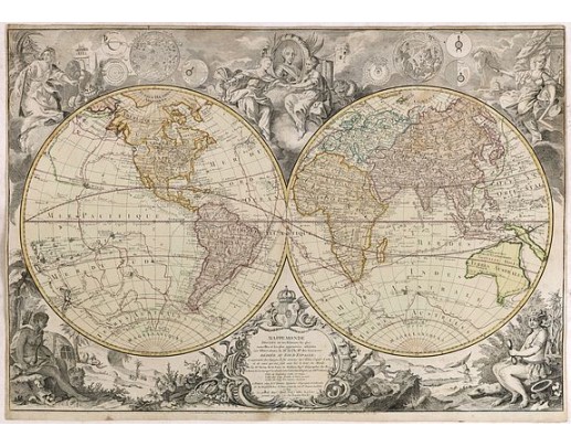
DESNOS, L.C. - Mappemonde Dressée sur les Relations les Plus Nouvelles et les plus approuvées assujeties aux Obserations de Mrs. De L'Académie Royale des Sciences.
 Click on image to zoom

DESNOS, L.C. - Mappemonde Dressée sur les Relations les Plus Nouvelles et les plus approuvées assujeties aux Obserations de Mrs. De L'Académie Royale des Sciences.
Published: Paris, 1789
Size: 520 x 760mm.
Color: Coloured.
Condition: Short margins with some usual age toning.
Description
Dated 1761, this state is unknown. "Desnos' includes a fine combination of up to date cartographic information and the routes of important 18th century voyages of exploration, along with several of the great cartographic myths and misconceptions.
The discoveries of Tchirkow, von Strahlenberg and De L'Isle de la Croyere accurately document the Russian explorations in the region are noted, with the first Russian explorations in the region dated 1731.
The explorations of the French Captain Nicholas de Frondat are shown. Frondat, who was captain of the Saint Antoine, had gone as far as China and Japan to trade. On his way back, following a northern route, even more northern than the route taken by the Manila Galleon, he was able to observe the islands off California, as stated in his logbook, the first Frenchman to make this route. To the south, in the Pacific, the routes of Anson, Magellan, and Le Maire & Schouten are shown, tracking from the Chilean Coast to Southeast Asia, after crossing from the Atlantic to the Pacific. In the South Atlantic, the route of the French explorer Jean-Baptiste Charles Bouvet de Lozier is shown. Bouvet left France in 1738, with the intent of making discoveries in the so-called South Seas which could accomodate French trading vessels enroute to Asia. He is credited with the discovering the Cape of Circumcision (Bouvet Island), although he fell considerably short of the Antarctic Coastline he sought. The map shows the icebergs and lands spotted by Bouvet in December 1738 and January 1739."
4,000€
- See other items by this publisher: DESNOS, Louis Charles
- Reference N°: 34935
