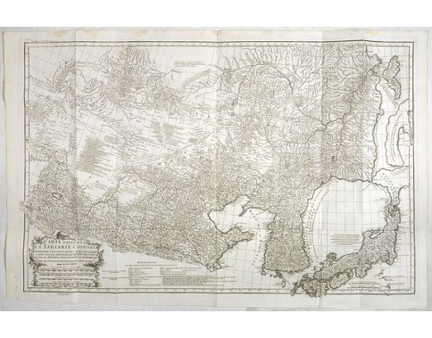
D' ANVILLE, J-B. Bourguignon d'. - Carte Generale De La Tartarie Chinoise Dressee sur les Cartes Particulieres Faits Sur Les Lieux Par Les R.R. P.P. Jesuites . . . .MDCCXXXII
 Click on image to zoom

Description
The map shows the vast expanse of China and its adjoining territories known collectively as Tartary, a term used by Europeans until the 19th century to denote a vast region spanning from the Caspian Sea and the Ural Mountains to the Pacific Ocean, inhabited mostly by Turkic and Mongol people.
d'Anville used maps prepared by Jesuit missionaries and commissioned by Emporer-Kangxi, who, from 1708 to 1716, ordered a survey of the country. Jean-Baptiste Regis (1664-1738) produced a map that appeared in the Kangxi atlas, was used and edited by d'Anville, and was published in 1735 in du Halde (description de la Chine).
The map is important as it shows Dokdo as "Tchian-chan-tao," which is a Chinese pronunciation of "Usando," an old name of Dokdo, together with "Fan-ling-tao," a Chinese name for Ulleungdo Island. Korea is spelled by several names, including "Kaoli Koue" (country of Goryeo), "Royaume de Coree" (Kingdom of Korea) and "Tchao-Sien".
Jean Baptiste Bourguignon d'Anville (1697-1782) engraved his first map at the age of fifteen and produced many maps of high quality throughout his career. He became the finest cartographer of his time and carried on the French school of cartography developed by the Sanson and the de L'Isle families. Although he never left the city of Paris, he had access to the reports and maps of French explorers, traders, and missionaries. During his long career, he accumulated a large collection of cartographic materials that has been preserved. He was interested in Asia and produced the first reasonably accurate map of China in 1735.
He became Royal Geographer and Cartographer to the King of France in the middle of the eighteenth century, when French cartography was still considered the best in the world. He was the successor to Guillaume Delisle as the chief proponent of scientific cartography, and his influence on his contemporaries was profound. D'Anville was the finest cartographer of his time, "his attention to detail was exemplary, his maps having a great delicacy of engraving" (Tooley).
This state of the map is from the very rare Atlas Volume of "Histoire générale de la Chine, ou Annales de cet empire, traduites du Tong-Kien-Kang-Mou, par (...) J.A.M. de Moyriac de Mailla, jésuite françois (...): publiées par l'abbé Grosier (...): revues & publiées par Le Roux des Hautesrayes" and published in 1785.
The text volumes are a reissue of the d'Anville's description of China. The maps are printed from the same copper plates. In upper left corner "N°26 Descript. Gén de la Chine pag.91."
- Reference N°: 38840
