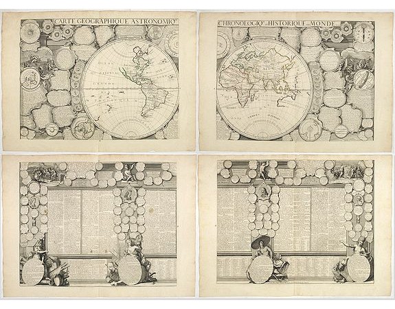
CRÉPY, Etienne-Louis - Carte Geographique Astronomique Chronologique et Historique du Monde.

CRÉPY, Etienne-Louis - Carte Geographique Astronomique Chronologique et Historique du Monde.
Published: Paris, Crépy, 1720
Size: 950 x 1250mm.
Color: In original o/l colours.
Condition: 4 sheets when joined 950 x 1250 mm. Orig. outlines col. Very good and dark inpresssion.
Description
French wall map of the world in 4 sheets published by Crépy "à l'entrée du Cloistre de St. Benoist du côté des maturins". A decorative wall map of the world surrounded by two biblical scenes, representations of the four continents, and numerous medallions with historical facts. Crépy family were geographers, engravers, publishers and map sellers of Paris and Marseille. ,Size of image when joined 950 x 1264 mm / 37.4 x 49.8 inches.
WORLD MAP TOGETHER WITH 4 CONTINENT MAPS.
Carte Geographique Astronomique Chronologique et Historique du Monde.
Size of image when joined 950 x 1264 mm / 37.4 x
49.8 inches. Paris 1720. Four sheets when joined 950 x 1264 mm / 37.4 x 49.8 inches. This extremely rare wall is surrounded by a wealth of information and two biblical scenes,
representations of the four continents, and numerous medallions with
historical facts.
AMERIQUE Les Francois Possedent en Cette Partie le Canada, la Floride, Partie de Nouv. Bretagne et de l'I. de Terre Neuve… Paris, 1735. Size of the image 520 x 650mm.
A rare separately published map of the western hemisphere, including parts of western Europe and Africa. Portraits of explorers, such as Jacques Marquette, Louis Joliet, and Robert Cavelier de La Salle, and coats of arms appear in an illustrative vine pattern along the left side. Large blocks of text adorn most of the map, including descriptions of the portraits along the left side, and a description of the Americas. The title cartouche shows a native Indian figure set against a foliate background. In the cartouche itself, a text lists all the colonial possessions by country.
California is shown as a large island.
Carte generale de L'AFRIQUE contenent Les Principaux Etats… (INSELIN, Charles / CREPY [Family].) Paris, 1735. Size of the image 520 x 650mm.
A rare separately published map of Africa prepared by Charles Inselin and published by Crepy in 1735. Decorated with the coats of arms, in medallions, of major countries of Europe and Northern Africa. The title cartouche is ornated with a native figure with an elephant.
Carte general de l EUROPE : divisé en ses principaux estast et subdivisé en ses principalles province / dréssé sur les mémoires les plus nouveaux par Inselin. (INSELIN, Charles / CREPY [Family].) Paris, 1735. Size of the image 520 x 650mm.
A rare separately published map of Europe prepared by Charles Inselin and published by Crepy in 1735. Decorated with the coats of arms of major cities, regions and countries of Europe. Includes Iceland.
Carte de L'Asie avec lettendue de ses principaux pais... (INSELIN, Charles / CREPY [Family].) Paris, 1735. Size of the image 520 x 650mm.
The great Jesuit surveys of China and the Far East revealed by d'Anville in his Nouvel Atlas de la Chine
(1737) must also here have provided important sources of geographical
materials. D'Anville rejected de Vries' assumption that the coastline of
Sakhalin was continuous with that of Hokkaido.
The wall map is of interest for the use of "Mer de Corée"
This rare set of 4 continent maps on the double sheet and the world map on 4 double sheet maps is extremely rare. The maps are in mint condition.
The wall map is of interest for the use of "Mer de Corée"
This rare set of 4 continent maps on the double sheet and the world map on 4 double sheet maps is extremely rare. The maps are in mint condition.
The maps are published by Crepy (probably Étienne-Louis) in Paris "chez Crepy rue St. Jacques a St. Jacques", dated 1735.
Étienne-Louis Crépy (1706-1759). Geography engraver, publisher and print-seller. Son of Jean Crépy from whom he bought the geographical part of his fund in 1731.
Étienne-Louis Crépy (1706-1759). Geography engraver, publisher and print-seller. Son of Jean Crépy from whom he bought the geographical part of his fund in 1731.
25,000€
- Reference N°: 63024
10259 views
Tags:
CRÉPY
, Etienne-Louis - Carte Geographique Astronomique Chronologique et Historique du Monde.
, World
 Click on image to zoom
