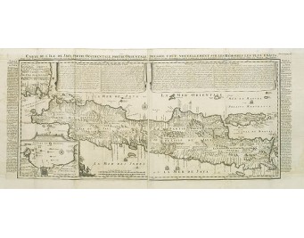
CHATELAIN, H. - Carte de l'Ile de Java.
 Click on image to zoom

CHATELAIN, H. - Carte de l'Ile de Java.
Published: Amsterdam, 1720
Size: 376 x 865mm.
Color: Coloured.
Condition: Printed from two plates. Paper slightly browned. Very slight oxidation due to offsetting of ink. Small hole (8x8mm.) filled in. A good and dark impression. Wide margins.
Description
An inset plan of Batavia and clearly indicated rice fields, mountains, forests, towns in profile and even elephants suggest the wealth of detail found on this map. Modeled on Hadrien Reland's important Dutch map of a few years earlier, the superb topographical detail is complemented by drapery style cartouche and side panels which provide a full French text description of the island, its topography, history, flora, fauna and inhabitants.
One of the finest large-scale maps of Java, giving good information regarding the V.O.C. settlements, each indicated with a flag in national 3-colour.
From Chatelain's Atlas Historique et Méthodique .
One of the finest large-scale maps of Java, giving good information regarding the V.O.C. settlements, each indicated with a flag in national 3-colour.
From Chatelain's Atlas Historique et Méthodique .
1,150€
- See other items by this publisher: CHATELAIN, H.
- Reference N°: 31300
